Disputed state in the north of India, area 139,000 SqKm (53,700 SqMi), population 6 million (1981). The state is bounded to the west by Pakistan and the 1971-72 Line-of-Control which separates it from Azad Kashmir; in the east by Ladakh, Tibet and Aksian Chin. The state is drained by numerous rivers including Indus, Zanskar, Suru, Nubra and Shyok
| State Capital | Srinagar (Summer), Jammu (Winter) | ||
| Population ('000s in 1991) | approx. 7,720,000 | ||
| Area ('000 sq. km) | 222,236 sq km | ||
| No. Of Districts | 14 | ||
| Literacy rate (1991) | 27% | ||
| Cities | Jammu, Srinagar, Udhampur, Poonch | ||
| Airports | Jammu, Srinagar and Leh | ||
| Railway | |||
| Total Railway track length | 72 kms | ||
| Number of Railway Stations | 7 Stations | ||
| Road | |||
| Total road network | 12,209 Kms | ||
| Number of National Highways | 3 | ||
| Air | |||
| Domestic Airports | 3 | ||
| Location: | Srinagar, Jammu, Leh | ||
| Communication | |||
| Number of Post Offices | 1567 | ||
| Number of Telegraph Offices | 369 | ||
| Number of Telephone Exchanges | 155 | ||
| Power | |||
| Installed capacity | 296(MW) for the year 1991-92 | ||
| Electricity Generated | 982(MUs) for the year 1991 | ||
|
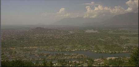
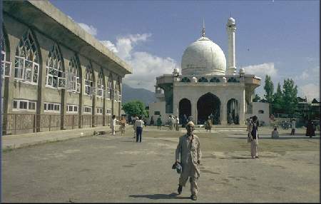
Srinagar is the summer capital whilst Jammu is the winter capital of the state. The state is divided into districts of which there are six in the Srinagar area, six in the Jammu area and two in Ladakh. The state was governed by a bicameral state government of 36 member Legislative Council and 76 member Legislative Assembly. The last government was led by Dr Farooq Abdullah of the National Conference party. However, in 1990, the government was dissolved and the state placed in the direct control of the state governor. There were no elections since 1990 and the state remained in the control of the governor under the Indian regime. However, elections were held in 1996 when through rigging and paramilitary pressure, India was able to implement a puppet state government headed by Dr Farooq Abdullah of the National Coneference. All Pro-Freedom parties were banned from these elections and their leaders placed under custody during the polling. Nearly 80% of the people are involved in agriculture, producing rice, wheat, wheat, maize and fruit; there are also valuable forests. Most of the manufacturing industry is based in and around Jammu. The state specialises in traditional handicrafts such as silk-spinning and carpet weaving. Due to the heavy conflict with the Indian authorities and the heavy-handedness of the Indian troops, the states agriculture and industry has declined since 1990. Srinagar and Jammu are connected via a road (305 Km/190 Mi) which passes through the Bahnihali mountains and the Jawahar tunnel and leads into the Vale of Kashmir . SrinagarSrinagar is the summer capital of Indian Occupied Jammu & Kashmir. The city is in the centre of the Vale of Kashmir, stranding on the banks of the river Jhelum, nested in the mountains, 112 Km (70 Mi) from Bahnihali pass and 1,585m (5,200 ft) above seal-level. Srinagar is criss-crossed by lakes, canals and bridges and is surrounded by beautiful gardens & Tourist Paradise, and has often been compared to Venice.Srinagar Map.
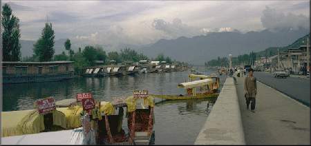
At the edge of the city lies the famous Dal Lake (8Km by 4Km) which houses the numerous houseboats. The houseboats, dating back to the British period, are an experience in themselves for the visitors with all the amenities and luxuries on board.
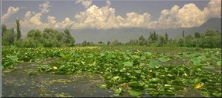
To the east of the city is located the smaller Nageen Lake which also houses houseboats. Both lakes have varied fauna and flora. Lotus flowers are in abundance around the lakes whereas in some areas of the lakes, vegetables are grown on floating pieces of land. The lakes are visited by paddle boats or, more commonly, by Shikaras (luxury boats with canopies especially used for visitors).
Gulmarg
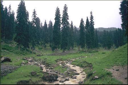
About 51 Km from Srinagar and standing at 2,730m above sea-level, Gulmarg is ringed by tall firs, pines and snow-capped mountains. Gulmarg is famous for its beautiful meadows, golf course and its skiing resort. The Nanga Parbat mountain can be seen from here. Pahalgam
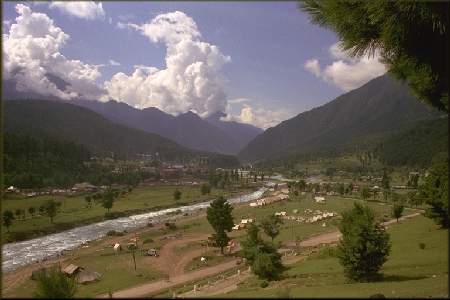
About 97 Km from Srinagar, standing at 2,195 m above sea-level, at the junction of the Lidder and Sheshnag rivers lies the beautiful town of Pahalgam. The surrounding area is full of beautiful meadows, tall pines and fir trees.
Pahalgam is the starting point for the annual Hindu pilgrimage to the Amarnath caves. The first stopping point for the pilgrims is at Chandarwari, 13Km from Pahalgam. Here snow bridges and glaciers can be seen even in the summer.
|
|||
 |
|||
This site is maintained by Muhammad Noman (mnomi5@hotmail.com). Comments and suggestions always welcome. |